Climate resilience has emerged as a key priority for the Biden administration. President Joe Biden has announced an ambitious goal to cut the nation's greenhouse gas (GHG) emissions in half by 2030, while the Build Back Better Act (BBB) sets aside $495 billion for a variety of climate initiatives, including tax incentives to transition energy production away from coal and natural gas and toward solar and wind, energy-efficient building retrofits, and electric vehicle tax credits. The BBB also calls for substantial investments ($166 billion) in housing by upgrading the nation's aging public housing stock and expanding subsidies to low-income renters.
However, the BBB largely ignores an essential channel through which housing impacts climate change: our land use and housing development practices.
Three features of land use and housing development are particularly important for reducing GHG emissions. First, building homes near job centers and public transportation reduces vehicle miles traveled—a major source of GHG emissions. Second, mixed-use development that integrates housing with stores, restaurants, and services allows people to run daily errands and socialize by walking or cycling instead of driving. Third, small homes—including townhouses, duplexes, and apartments in multifamily buildings—use less energy than single-family detached homes.
To illustrate the failings of our current system, we analyze where new housing has been built and what type of structures that new housing is across the Atlanta, Chicago, and Washington, D.C. metro areas. We found that over the past 30 years, most new homes in these metro areas have been built in suburban and exurban communities, with single-family homes making up roughly 70% of new homes—exactly the opposite of climate-friendly growth.
SPATIAL PATTERNS OF JOBS AND PUBLIC TRANSPORTATION AFFECT HOUSING GROWTH AND CLIMATE IMPACTS
To think about what climate-friendly housing growth would look like in Atlanta, Chicago, and Washington, D.C., we start by considering the spatial patterns of economic activity, especially employment and public transportation infrastructure. These features are extremely durable and evolve slowly over time, because building new transportation or shifting job centers is a slow and costly process.
The three metro areas offer contrasts in urban spatial patterns. Chicago and Washington, D.C. have relatively centralized employment, with a large share of jobs in the downtown core. Atlanta is what urban economists call a "polycentric" metro area, meaning that jobs are dispersed across multiple subcenters rather than one dominant core.
All three metro areas have large suburban job centers as well, mostly located along highways and distributed unevenly across space. Atlanta's job centers are more prevalent on the north side of the city (Midtown and Buckhead) and northern suburbs (Decatur in DeKalb County, Marietta in Cobb County). Chicago’s suburban job centers cluster north and west of downtown, with a large concentration around O'Hare International Airport. In the Washington, D.C. metro area, the largest subcenters include Tysons Corner, Va. (west of downtown Washington, D.C.) and a corridor stretching from Bethesda to Rockville in Montgomery County, Md. (northwest of downtown).
Rail transit systems in the three metro areas vary in their size and age (Figure 1). Because land use changes slowly over time, metro areas with older transit systems tend to have a higher concentration of jobs, retail, and housing clustered near rail stations. Both Chicago and Washington, D.C. have traditional hub-and-spoke systems, designed to move commuters living in the suburbs to downtown job centers. Chicago has by far the largest and oldest transit system of the three, with more than 350 rail stations developed over the past 100 years. The Chicago Transit Authority serves the urban core; Chicago’s downtown Loop has the highest density of stations and most frequent service. The commuter rail system extends into suburban and exurban communities in Illinois, Indiana, and Wisconsin.
The Washington, D.C. Metrorail system was largely developed during 1970s and 1980s, with modest expansions through the early 2000s and most recently, 2014. The urban core—the District, Arlington County, Va., and Alexandria, Va.—has the highest density of stations, with less densely placed stations along suburban "spokes".
Atlanta's MARTA transit system is the newest and smallest of the three. Most of its 39 stations were developed between the late 1970s and early 1990s, with moderate expansions in the early 2000s.
The Chicago metro area has the most extensive rail transit network.

Understanding the spatial patterns of jobs and public transit offers insight into what climate-conscious housing development might look like across the three metro areas. In Chicago and Washington, D.C., homes built in the urban core and along key transit spokes that connect to large suburban job centers create the greatest opportunity for non-car-dependent commutes. However, in the Atlanta metro area, nearly two-thirds of MARTA stations are located within the city of Atlanta, providing limited connections to major suburban job centers. Unsurprisingly, Atlanta has the highest share of commuters who drive in single-occupant cars (77%), followed by Chicago (68%) and Washington, D.C. (63%).
Because suburban job centers are not evenly spread in all directions from Atlanta's downtown, the suburbs that see more housing growth matter for commuting patterns. For instance, homes built 20 miles south of downtown Atlanta are likely to require longer commutes than homes built at a similar distance in the northern suburbs.
Neighborhoods located in the urban core of all three metro areas (even low-density Atlanta) have better integration between homes and retail/services, as well as better pedestrian and cycling infrastructure (e.g., sidewalks, crosswalks, protected bike lanes). Therefore, housing added through infill development in the urban core is more likely to enable car-light lifestyles for daily errands and socializing, as opposed to housing in low-density suburban or exurban neighborhoods with greater distances between homes and commercial activity.
CHICAGO HAS BUILT MORE HOUSING IN THE URBAN CORE, WHILE ATLANTA AND WASHINGTON, D.C. FAVOR THE SUBURBS
Figure 2 shows Chicago, Atlanta, and Washington, D.C.'s geographic patterns of housing production across the past three decades. In all three metro areas, new housing permits expanded during the 1990s and early 2000s, fell precipitously during the mid-2000s as the Great Recession disrupted housing production, and have slowly recovered since. The persistently low levels of production—even in metro areas with strong labor markets and population growth—are a worrying sign for housing affordability.
Breaking out production across urban, suburban, and exurban communities shows notable differences between Chicago on the one hand and Atlanta and Washington, D.C. on the other. Suburban and exurban communities built much more housing than the urban core in both Atlanta and Washington, D.C. during most of the study period. Over the entire period, the urban core accounted for about one-third of new permits in Chicago, compared to about 15% of permits in Atlanta and Washington, D.C.
However, the urban core makes up a larger share of new housing post-Great Recession in all three metro areas. Since 2010, permits in the urban core were nearly half of total permits in Chicago and more than one-quarter of total permits in Atlanta and Washington, D.C. These trends are consistent with increasing demand for high-amenity central cities across much of the U.S.
In the Atlanta and Washington, D.C. metro areas, most new housing was built in suburbs and exurbs.

The potential climate impacts of new housing are mixed across the three metro areas. Chicago has consistently performed best at adding housing close to downtown jobs and public transit. The Washington, D.C. region has a similar job and transit distribution to Chicago, but has added most new housing in distant exurbs. And in Atlanta, because the suburbs are home to a larger share of jobs, it is less clear whether suburban and exurban housing development led to a spatial mismatch between jobs and homes. Some suburban job centers there, such as Decatur and Marietta, added substantial amounts of new housing and grew in population.
CENTRAL CITIES ACCOUNT FOR MORE THAN HALF OF HOUSING PRODUCTION WITHIN THE URBAN CORE
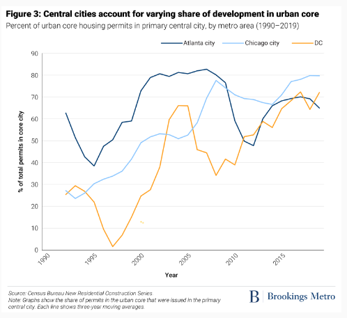
Central cities have become consistently larger housing producers in Chicago and Washington, D.C., while Atlanta's production exhibits more ups and downs during the study period (Figure 3).
Housing permits in the city of Chicago and the District of Columbia grew from about 30% of the urban core in the early 1990s to 70% and 80%, respectively, in the late 2010s. For context, Chicago accounts for slightly more than half the urban core's population, while the District is home to just over 60% of population living in the Washington, D.C. metro area's urban core.
By contrast, the city of Atlanta's share of housing production in the urban core has seesawed between 40% and 80% without a clear time trend. Roughly 60% to 70% of the urban core population lives in the city of Atlanta, with the remainder in other parts of Fulton County.
Central cities account for varying shares of development in the urban core.

CHICAGO'S SUBURBAN DEVELOPMENT IS FRAGMENTED, WHILE WASHINGTON, D.C.'S IS CONCENTRATED
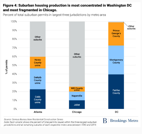
The degree of fragmentation in suburban development varies widely across the three metro areas (Figure 4).
In the Washington, D.C. suburbs, nearly 99% of housing growth is split among three large counties: Fairfax County, Va., Montgomery County, Md., and Prince George’s County, Md. (Almost all land in these three counties is unincorporated, meaning that county governments have primary responsibility for regulating land use and housing development.) In Atlanta, the three largest jurisdictions—unincorporated parts of Cobb, Dekalb, and Henry counties—account for about 60% of all suburban development. The Chicago suburbs exhibit the most fragmentation: There are 76 separate political jurisdictions in the suburbs, and the three largest suburbs collectively account for only 25% of development.
Development in exurban regions reveals similar patterns of fragmentation. Washington, D.C.'s exurban development is concentrated in a few large counties, while Chicago's exurban housing growth is spatially dispersed across many small jurisdictions (results available from authors upon request).
Suburban housing production is most concentrated in Washington, D.C. and most fragmented in Chicago.

The degree of local government fragmentation within a metro area impacts housing markets through two (somewhat related) channels. First, there are economies of scale in providing some kinds of locally funded public services and infrastructure, such as water and sewer systems, schools, and public safety. Building new housing increases the demand for these services, which are typically funded by a mix of property taxes and impact fees. Very small communities thus face higher per capita costs to expand services when new housing is built, leading to either higher local tax rates or lower quality of services.
Second, the political and fiscal incentives of small, primarily residential communities may not align with larger regional needs. For instance, local elected officials can face political pressure from current residents to limit development of housing that is affordable to low-income families, which is perceived as a net fiscal cost. Yet regional labor markets need a certain amount of housing that is affordable to workers at all income levels. In highly fragmented metro areas, it is easier for each small community to assume that its neighbors will provide those regional needs.
SINGLE-FAMILY HOMES CONSTITUTE A MAJORITY OF HOUSING DEVELOPMENT IN ALL THREE METRO AREAS
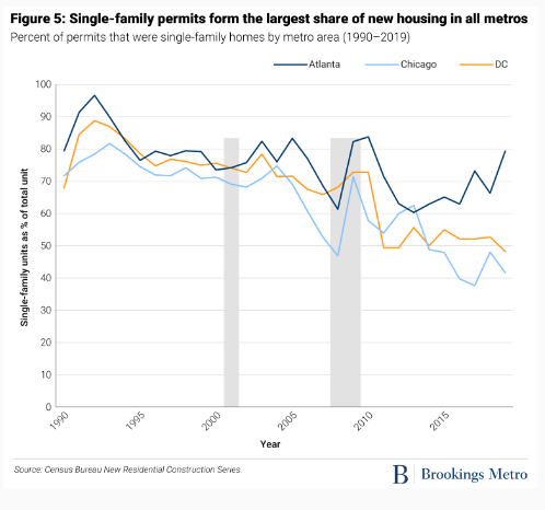
Across U.S. metro areas, the vast majority of land is zoned exclusively for single-family detached homes, which are the largest and most expensive type of structure. (The dataset we use groups single-family detached houses and attached townhouses together.) Accordingly, in the three metro areas we studied, single-family homes accounted for roughly 70% to 80% of new development from 1990 to 2005 (Figure 5).
Since 2010, however, the share of single-family homes in the Chicago and Washington, D.C. metro areas has steadily declined, to about 40% to 50% of new development. This reflects shifts in the location of development toward the urban core, where multifamily housing is more common (and more likely to be allowed under zoning).
Single-family permits form the largest share of new housing in all three metro areas.

Over time, all three metro areas have seen increases in the share of new homes in multifamily buildings, defined here as buildings with five or more units (Figure 6). This reflects both rising numbers of multifamily permits and decreasing numbers of single-family permits.
In the past several years, policymakers have shown increasing interest in "missing middle" housing—often defined as duplexes and three- to four-family homes. Production of two- to four-family homes was indeed missing in the Atlanta and Washington, D.C. metro areas over the past 30 years, accounting for less than 1% of development. In the Chicago metro area, about 6% of new permits are in two- to four-family buildings—tiny relative to single-family and large apartments, but noticeably larger than the other two metro areas. Nonetheless, the limited production of these "missing middle" housing types raises questions about the potential impacts of recent zoning reforms aimed at legalizing these structures.
Chicago has built the most two- to four-family homes.

FEDERAL AND STATE POLICIES COULD NUDGE MORE CLIMATE-FRIENDLY HOUSING DEVELOPMENT
Ideally, federal housing policy would support building enough housing in places with strong demand to accommodate population and job growth, while discouraging development in environmentally harmful or risky locations. In practice, the U.S. is struggling to achieve either of these goals.
The Build Back Better Act does include one small ($1.75 billion) new program, Unlocking Possibilities, which is aimed at encouraging better land use. Structured as a competitive grant program, states and localities can receive funding to revise their zoning and land use plans. This is a welcome preliminary step to boosting supply; even better would be making funds contingent on improving measurable housing outcomes (e.g., additional homes produced, reduced prices).
The Biden administration should be realistic about how much direct influence the federal government has over housing production. Land use policies that drive climate-unfriendly housing (such as prohibitions on apartment buildings, large minimum lot sizes, and minimum parking requirements) are primarily the responsibility of local governments. State governments create the legal and fiscal framework within which cities and counties operate, so states are better positioned to incentivize zoning reforms.
The federal government has more effective levers over—and devotes vastly more resources to—transportation policy than housing and land use. The Department of Transportation should require all local and state agencies that receive federal funding for public transportation to coordinate transit investments with land use. Why spend money building subway, light rail, or bus rapid transit systems in locations that prohibit moderate-density mixed-use housing and commercial development?
Another promising provision in the BBB, the Affordable Housing Access program, offers grants to improve transit access to low-income neighborhoods. In low-density, polycentric metro areas like Atlanta, providing high-frequency reliable bus service between affordable housing and suburban job centers could expand economic opportunity faster and more cheaply than expanding rail service.
Strategic federal investments and better coordination of funding streams across transportation, land use, and housing have the potential to simultaneously increase climate resilience and reduce economic stress for American families—both critical goals for a better future.
今年1月,新冠疫情突然而至。为了防止疫情扩散,我国采取了史无前例的交通阻断及人流限制措施,这也为我国农业农村经济发展带来了巨大挑战。
